Home > Desert & Canyon > San Rafael Swell > Quandary Canyon / Ramp Canyon  
  Quandary Canyon (w/Ramp Canyon return)


Photo © Jon Cox
Total Distance: 11 miles if returning through Muddy Creek; approximately 9 miles if returning through Ramp Canyon
Time Needed: 8-12 hours depending on pace and experience levels
Rating: Moderate to Difficult depending on the route chosen
Elevation Difference Approximately 1600 feet


Photos of this hike

by Jon Cox
Introduction

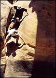
Although it is true that novice hikers should not attempt Quandary Canyon, Steve Allen's description of this adventure as one for only the truly proficient canyoneers seems quite inaccurate. "Obstacles" do abound. However, one thirty-foot strand of webbing was more than sufficient to get us safely down each minor cliff. Allen's description led us completely around the "major obstacle", the only really gnarly part of the course where actual ropes, harnesses, and rappelling equipment would be necessary.

In fact, it would be entirely possible for an experienced climber and canyoneer to race the whole canyon, following Allen's route description, in a few short hours without any protection or serious gear. If, on the other hand, a party chose to attempt the major obstacle Allen directs people to avoid, they should be prepared for an apparently arduous adventure worthy of Allen's strongest warnings. Which of course, looking back up canyon at that obstacle made us wish we had attempted it, and caused us to make plans immediately to return again to "test our mettle." Nevertheless, the quality of the scenery and views, as well as the excellent diversity of obstacles and skills exercised in navigating his described route were well worth the sacrifice of skipping the Major Obstacle, and will keep me coming back for years.

With that qualification, Allen's description of the hike is sparse but adequate. The following notes and comments are meant as supplemental information.

Directions to Trailhead

Road directions are accurate, however, we found that the "impassible" spot on the road before the beginning of the hike has been rendered "passable" by the ingenious human trick of creating a new road around the old spot. At this point, the damage has already been done, so hikers can save themselves a mile of hot walking by following the road up to the trailhead instead of parking earlier.

The actual trailhead is not visible until after you have passed the "impassible" spot on the road. It comes into view off to the right about a half-mile ahead in a beautiful hidden alcove with a notch noted by Allen at the far side.

Park at the obvious trailhead and make a bee-line for the notch at the far end of the alcove. The track leading up into the canyon is obvious once you start into the alcove.

Route Notes

  • Although Allen mentions the first obstacle early in the hike description, it still came as a surprise, just how close it is to the beginning of the hike. Be prepared to stop and work out a descent almost before you have even begun to hike. There is a fairly easy climbing descent route on the left wall of the canyon, looking downstream, just past the lip of the fall.
  • The second obstacle follows shortly after the first. Be prepared for another very brief hike. Again, it was somewhat of a surprise just how close they were.
  • Allen's hike description is somewhat sparse. There are numerous obstacles that could delay inexperienced hikers for hours. Be prepared to tackle repeated short falls and potholes with only short stretches of beautiful hiking in between. Many of these obstacles do not show in Allen's description, which sometimes left us wondering if we were seeing something he was describing or another more minorly difficult section.
  • The water in the pothole that Allen asserts the necessity of swimming was indeed quite cold, however, the walls are narrow and it is possible for an experienced canyoneer to bridge across the walls above the pool and not fall into the drink.
  • At the point where Allen directs hikers to avoid the major obstacle by climbing up a draw on the left side of the canyon, there is a anchor buried in the sand at the lip of a pothole with a piece of webbing attached. This is the point where the group must decide whether to tackle the major obstacle or traverse around. It is highly unlikely that a group will be able to navigate the major obstacle, a cascade of potholes descending approximately 300 vertical feet at about a 35-degree angle, without extensive knowledge of rope and rappelling techniques. This is should not be attempted without the proper technique and equipment!
  • In contrast, the alternate route, described by Allen, is quite tame and proffers a stunning view of the southern end of the swell and areas beyond. However, even this route requires a bit of route-finding and pluck because it, too, descends rapidly to the canyon below. An incredible view of the major obstacle, looking back upstream, is also available from this route.
  • After the major obstacle, there is only one more falls that provides any difficulty. This is a wide bowl with a large cottonwood tree at the bottom. The easiest routes down from this bowl are to traverse either to the left across the natural ledge at the top of the bowl for approximately 300 feet and then work down into the canyon again, or to descend the first ramp to the right, and then climb up another ramp to the right for approximately 40 vertical feet before traversing further to the right and descending another ramp into the bottom of the bowl. This route is not completely visible from the top of the bowl, and the first ramp descent is somewhat steep, so the traverse to the left may be the more safe and economical route.
  • Quick hiking from here takes you over minor obstacles to the end of the canyon and into the wash beyond the reef of the swell. Once in the wash hikers must choose to walk West along the wash to reach Muddy Creek and return to the car, or to walk up stream, East, along the reef to reach the alternate route of Ramp Canyon.
  • CAUTION: If you choose to return via Ramp Canyon, it helps to bring Allen's description of how to find the entrance to Ramp (read in Part 2 of hike #48 in Canyoneering). However, the directions assume you are coming from the opposite direction (from Cistern Canyon to the north), so it can be problematic to find the entrance. Coming from Quandary Canyon, you will bypass a number of narrow slot-like canyon openings. Ramp Canyon begins as a relatively wide wash to your left that cuts through a large, uplifted slab of bedrock. After walking up-canyon for about 5 minutes, you can verify you have found Ramp Canyon by looking for the distinctive reef formation Allen describes, where the streambed cuts directly East-West for approximately 100 yards alongside a tall layer of strata tilted at a 45-degree angle.
  • The hike between Quandary and Ramp canyons is almost longer than the hike up Ramp Canyon itself. Once you are in Ramp Canyon, it is only a matter of approximately an hour before emerging at the top. Then it is another 30 minute of hot hiking along the road to reach the parked car again.
  • Ramp Canyon requires an ascent of a steep slab that may be more difficult and intimidating than any obstacle in Quandary Canyon (aside from Quandary's "major obstacle"). Beginners be forewarned.
  • Although the distances are not long, Quandary Canyon provides enough obstacles to slow hiking time for all groups who are less than expert. Therefore, be sure to bring plenty of water and food to avoid a long dry walk back to the cars from the bottom of Quandary Canyon. Be safe and enjoy your surroundings.

  •  Recommended
    CanyoneeringCanyoneering
    by Steve Allen

    This guide deals with specific hikes/backpacks in the San Rafael Swell. It's probably the most accurate Utah trail guide around. We have now done well over 20 of the trips in this guide, and the trail descriptions were right on every time. It is well-written, clear, and concise.

    >>Click here see the book at Amazon.com

    >>View pages from Canyoneering

    >>More books about Utah's Canyon Country

     Site Categories
     To Do

    High Uintas Guidebook
    Click For Info

    A Guide to Climbing the 13,000-Foot Peaks of the High Uintas